Main article: Khmer Empire
Archers mounted on elephants
Map of South-east Asia c. 900 AD, showing the Khmer Empire in red, Champa in yellow and Haripunjaya in light Green plus additional surrounding states.
progress and achievements, political integrity and administrative stability. The empire represents the cultural and technical apogee of the Cambodian and Southeast Asian pre-industrial civilisation.
The Khmer Empire was preceded by Chenla, a polity with shifting centres of power, which was split into Land Chenla and Water Chenla in the early 8th century.[77] By the late 8th century Water Chenla was absorbed by the Malays of the Srivijaya Empire and the Javanese of the Shailandra Empire and eventually incorporated into Java and Srivijaya.[78] Jayavarman II, ruler of Land Chenla, initiates a mythical Hindu consecration ceremony at Mount Kulen (Mount Mahendra) in 802 C.E., intended to proclaim political autonomy and royal legitimacy. As he declared himself devaraja - god king, divinely appointed and uncontested, he simultaneously declares independence from Shailandra and Srivijaya. He established Hariharalaya, the first capital of the Angkorean area near the modern town of Roluos.[79]
Jayavarman II's successors continued to reside north of the Tonlé Sap lake. This population centre was subject to extensive urban planning, embedded in an elaborate hydraulic network of water reservoirs and canals around central monumental religious structures. The religious monuments underwent over the course of several centuries a sophisticated architectural, stylistic and aesthetic development of eventually most exquisite expression and mastery of composition.
Bakong, one of the earliest temple mountain in Khmer architecture
Royal administration was based on the religious idea of the Shivaite Hindu state and the central cult of the sovereign as warlord and protector - the "Varman". This centralised system of governance appointed royal functionaries to provinces. The Mahidharapura dynasty - its first king was Jayavarman VI (1080 to 1107), which originated west of the Dângrêk Mountains in the Mun river valley discontinued the old "ritual policy", genealogical traditions and crucially, Hinduism as exclusive state religion. Some historians relate the empires' decline to these religious discontinuities.[81][82]
The area that comprises the various capitals was spread out over around 1,000 km2 (386 sq mi), it is nowadays commonly called Angkor. The combination of sophisticated wet-rice agriculture, based on an engineered irrigation system and the Tonlé Sap's spectacular abundance in fish and aquatic fauna, as protein source guaranteed a regular food surplus. Recent Geo-surveys have confirmed that Angkor maintained the largest pre-industrial settlement complex worldwide during the 12th and 13th centuries - some three quarters of a million people lived there. Sizeable contingents of the public workforce were to be redirected to monument building and infrastructure maintenance. A growing number of researchers relates the progressive over-exploitation of the delicate local eco-system and its resources alongside large scale deforestation and resulting erosion to the empires' eventual decline.[83]
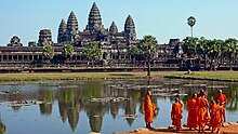
Buddhist monks at Angkor Wat
Portrait statue of Jayavarman VII
In August 1296, the Chinese diplomat Zhou Daguan arrived at Angkor and remained at the court of king Srindravarman until July 1297. He wrote a detailed report on life in Angkor. His portrayal is one of the most important sources of understanding historical Angkor as the text offers valuable information on the everyday life and the habits of the inhabitants of Angkor.[85]
The last Sanskrit inscription is dated 1327, and records the succession of Indrajayavarman by Jayavarman IX Parameshwara (1327 - 1336).
The empire was an agrarian state that consisted essentially of three social classes, the elite, workers and slaves. The elite included advisers, military leaders, courtiers, priests, religious ascetics and officials. Workers included agricultural labourers and also a variety of craftsman for construction projects. Slaves were often captives from military campaigns or distant villages. Coinage did not exist and the barter economy was based on agricultural produce, principally rice, with regional trade as an insignificant part of the economy.[86][87]


No comments:
Post a Comment